|
In my last post detailing the selection and design process for a multi-functional hedgerow on my developing homestead in Vermont's Champlain Valley, I described the 11.5 acre parcel, explained my goals and the desired functions for this 1/2 acre planting, and discussed the species selection process. Here I'll describe the way I came up with the planting layout and design for this project.
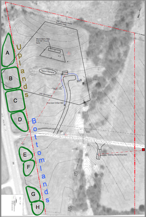
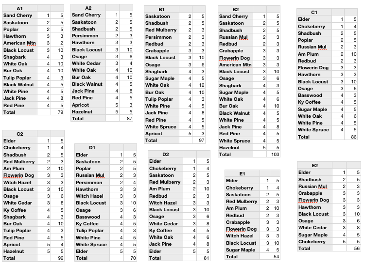
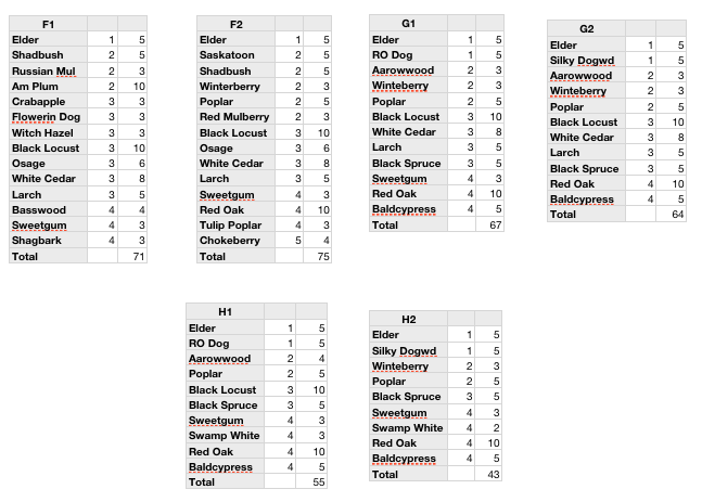
With such a broad diversity of species on the way, I looked for simple patterns I could use to break up the landscape into smaller, more manageable groupings. As the topo map of the site shows, the property has a southern orientation, and the slope transitions from being fairly steep - perhaps 12-15% grade along the northern 1/3 to somewhat flat 3-5% as you progress further south. My observations during the first season there had suggested that the steepness of the slope strongly correlated to the depth of the water table and the relative wetness of the soils. Generally, my site has heavy clay soils - called 'Vergennes clay' locally. A soil test carried out by Logan Labs in Ohio found that the lower part of the property is mineral rich with a high cation exchange capacity (13.28). pH is 6.2 and 7.36% organic matter. A soil particle analysis revealed the extent of the fines in the soil matrix - 44% clay, 44% silt and 12% sand. Probably the strongest single inspiration compelling me to experiment with such a diverse planting was the incredible species diversity in the 40 acres of woods I'd also purchased. This remnant patch of 'valley clayplain forest', a now relatively rare ecological community that once blanketed the vast majority of the Champlain Valley, supports close to 30 species of woody plants. Something of a transition zone between the northern hardwood communities comprised of birch, maple, beech, cherry and hemlock and the oak-hickory forests that cover large expanses of the forestlands further south, the heavy soils contribute to significant site productivity, despite the challenges of an often high water table. In short though, I knew this land is capable of supporting a broad diversity of woody plants. All this information suggested a fairly simple pattern by which to plan. I broke the ~850' long north-south planting belt up into 2 broad sections - 'uplands' and 'bottomlands' - based on the slope and observed tendency to pool water during heavy rain events. This gave me the ability to start to categorize species based on their soil moisture tolerances and start to develop a skeletal framework to design the planting. Secondly, I knew that I wanted the planting to have a 'stepped' character from west to east like the design of a classic shelterbelt/windbreak - starting with shrubs and small trees along the western edge, and steadily increasing in height to the east. I had planned a very dense planting - roughly 5-6' between individuals - because the primary function here was the privacy screen the plants would provide. Since I know that the planting will suffer some mortality, this gives me some wiggle room as well once gaps begin to develop. And because my main intention was not to manage for mature 'standard' trees but rather more of a thicket of coppice stools, this high density should allow me achieve high productivity in a fairly small space. After all, it's easy to cut down a tree if I find it too close to another 5-10 years down the line, but I can't easily (or economically) plant a 10 year old tree to fill in a missing gap. So at 6' spacings, this 30' wide belt would give me about 5 'rows' worth of plants from west to east. This gave me the other structural pattern I could use to start to refine my planting layout. I assigned each species a number based on the 'row' I deemed it best suited with 1 being the lowest row on the western edge, 4 being the tallest, and 5 being the position most interior to the property - the one for which I'll have most easy access. Since another key goal here is fruit/nut production, I chose to reserve the innermost row for species that provided this function - hazelnuts, plums, apricots, elderberry, serviceberry, crab apple, aronia, etc. This gives me the most convenient access to these plantings for grafting (none of these are selected cultivars), pruning, harvest, etc and it also gives them a prime solar position given that they will receive abundant sun from morning on through about 3 or so in the afternoon - even once the rest of the hedgerow is mature. With these 2 categorical divisions in place, I broke up the planting belt into eight 90'+ long belts and created a patch grouping for each zone along with projected numbers of individual plants I'd need (see attached tables). Because I'm hoping to ensure year-round privacy screening, I made sure to include at least one conifer species in each grouping, and upon planting, including one or more conifers in each individual 'row'. The attached site plan shows the rough distribution of the 8 planting blocks from north to south, and the tables show the 'plant community' blocks I developed. I broke each zone into 2 parts, each then theoretically representing half of the block (A1 and A2 for example). The first column lists the species, the second indicates the structural role they fill - level 1-5 depending on their positioning from west to east, and the third column shows the rough estimate for the number of individuals planted in each block (it turns out I overestimated the number of plants I'd need in the field by about 20% - I either planted these additional plants in nursery beds or potted them up). In the next installment, I'd discuss the strategies I used for site prep, in the field layout, and planting.
28 Comments
|


 RSS Feed